Contact us
Get in touch with our experts to find out the possibilities daily truth data holds for your organization.
Persistent Monitoring
Natural catastrophe solutions
Press release
Helsinki, Finland - March 31, 2025 - ICEYE, the global leader in satellite-powered disaster management solutions, has launched its industry-first hurricane data solution for weather events impacting the US.
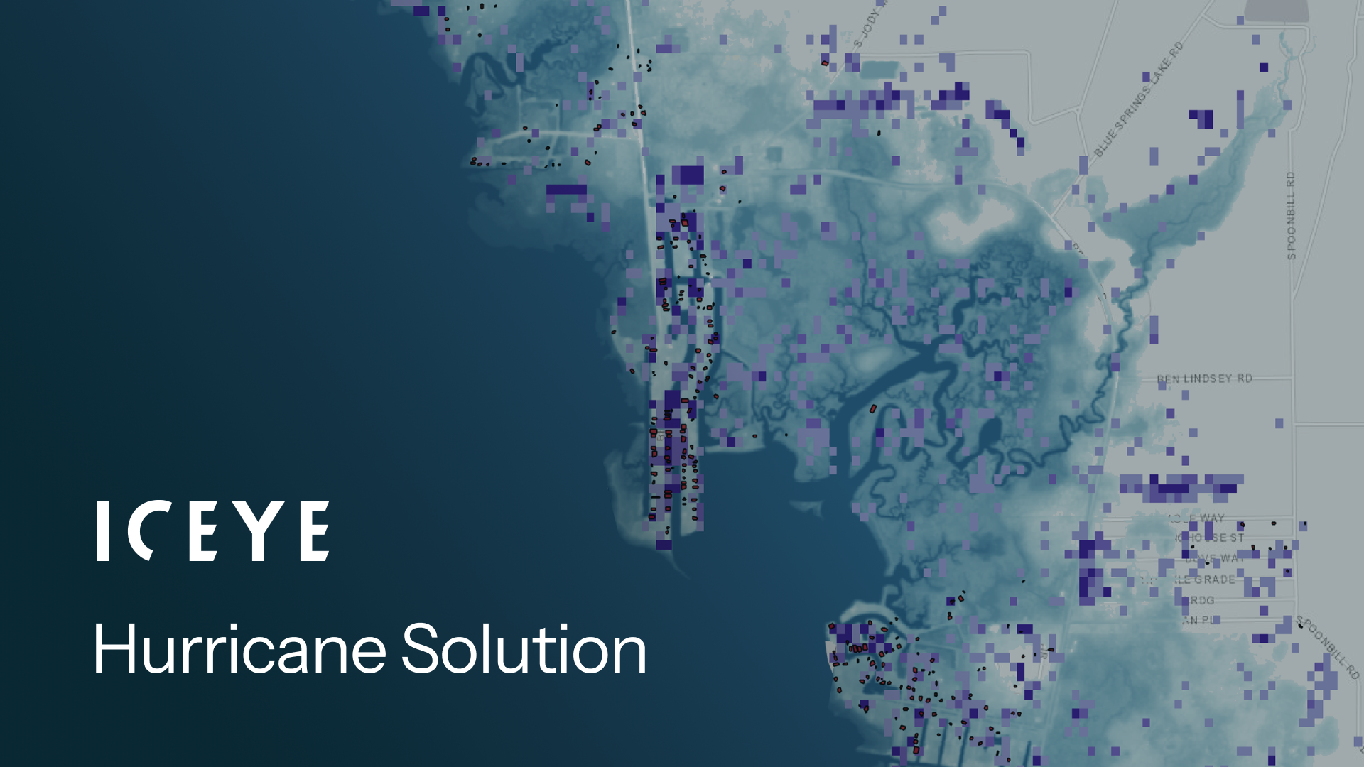
The Hurricane Solution provides insurers with impact information from both wind and flooding within 24 hours of a hurricane making landfall. Using high-resolution satellite imagery, ground-based data sensors, and auxiliary information, the solution delivers damage data across the full extent of the event, encompassing tens of thousands of square miles and pinpointing areas of major neighborhood and building impact along the hurricane’s track.
ICEYE’s unique synthetic aperture radar (SAR) technology enables on-the-ground monitoring through cloud cover and day or night for continuous impact assessment. The information enables users to overlay property portfolio data for the impacted regions with a heatmap at neighborhood blocks and at plot levels for building damage, plus a flood depth footprint measuring water levels in inches.
Instant access to this actionable data delivers full situational awareness days ahead of traditional information sources. Insurers can quickly establish the most severely impacted customers, identify large loss concentrations, and target field resources accordingly. Further, insurance carriers can conduct rapid claims triage and immediately identify complex claims that combine wind and flood losses to inform adjuster allocation and help reduce costs.
Rupert Bidwell, Vice President of Insurance Solutions at ICEYE, said: “Our Hurricane Solution offers insurers a completely new level of situational awareness as we head towards the 2025 hurricane season. Access to near real-time, large-scale damage data for both wind and flood within 24 hours of landfall can help supercharge every phase of the response from initial loss estimates to claims resolution. Ultimately, it helps insurers deliver an enhanced customer experience through more effective support, better claims triage, and faster settlement when they need it most. That’s truly game-changing.”
ICEYE delivers unparalleled persistent monitoring capabilities to detect and respond to changes in any location on Earth, faster and more accurately than ever before.
Owning the world's largest synthetic aperture radar (SAR) satellite constellation, ICEYE provides objective, near real-time insights, ensuring that customers have unmatched access to actionable data, day or night, even in challenging environmental conditions. As a trusted partner to governments and commercial industries, ICEYE delivers intelligence in sectors such as defense and intelligence, insurance, natural catastrophe response and recovery, security, maritime monitoring, and finance, enabling decision-making that contributes to community resilience and sustainable development.
ICEYE operates internationally with offices in Finland, Poland, Spain, the UK, Australia, Japan, UAE, Greece, and the US. We have more than 700 employees, inspired by the shared vision of improving life on Earth by becoming the global source of truth in Earth Observation.
Media contact
press@iceye.com
Other assets available at https://www.iceye.com/media-assets
Get the latest news and updates from ICEYE directly to your email. Don't forget to follow us on @iceyefi & on LinkedIn. For press inquiries and further materials please refer to our Press section.
