Contact us
Get in touch with our experts to find out the possibilities daily truth data holds for your organization.
.png)
Disclaimer: The impact numbers are subject to change as ICEYE continues to analyze the flood and extend the analysis area. Some areas which have been impacted by the flooding may not be represented in this initial data.
October 15, 2024
Our newest, sixth flood extent and depth analysis release will be delivered to our customers at 21:00 UTC on October 15.
Until then, based on our fifth data release, we estimate that the total flood extent is at least 1,900 square miles and there could be at least 150,000 buildings impacted by flooding Florida.


October 15, 2024
Eric Jensen, CEO of ICEYE US, joined CNBC's Manifest Space podcast hosted by Morgan Brennan to discuss how ICEYE works with insurance companies, intelligence, defense and civil society organizations around the world.
"Our imagery allows us to see what infrastructure is damaged, which roads are damaged, which ones are passable," describes Eric. "In the case of Helene, we're working with federal, state, local government agencies and also NGOs. We've directed over 60 rescue and emergency medical supply helicopter missions," he explains.
ICEYE SAR satellites can also be used to help assess large areas of land. Eric shares an example of how the Brazilian Air Force monitored illegal deforestation, "They're using our satellites to map and assess what illegal deforestation is happening in real-time. They've then created an analogue to what impact to GDP those illegal activities have, then justified resources to either interdict or prevent that from happening in the future."
Tune in to the 'Manifest Space: Hurricane Watch with ICEYE U.S. CEO Eric Jensen' podcast episode and learn more about what ICEYE can deliver.

October 11, 2024
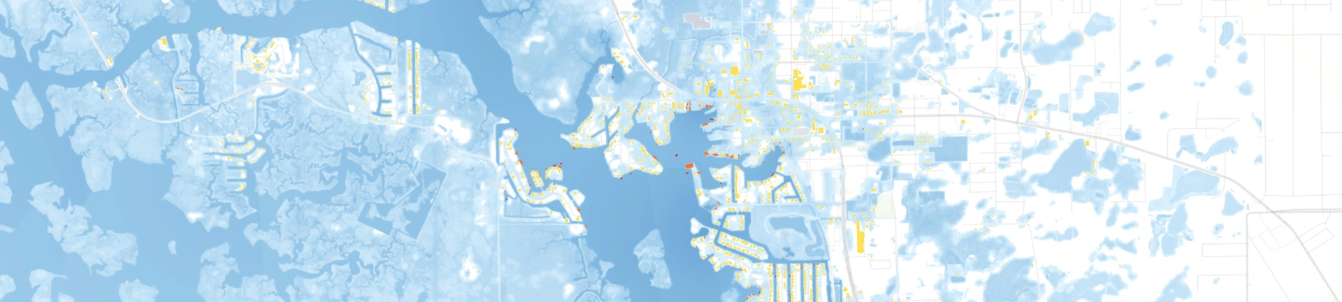
Hurricane Milton made landfall near Siesta Key, Florida, on the evening of October 9th, 2024. It struck as a powerful Category 3 hurricane with maximum sustained winds of 120 mph. The storm caused significant storm surges and widespread power outages across Florida’s Gulf Coast.
Before landfall, Milton had briefly intensified to Category 5 over the Gulf of Mexico, but it weakened as it approached the coast. The storm has since moved inland, reducing in strength but leaving extensive flooding and damage in its wake.
.png?width=1920&height=1080&name=Milton_R1_Hillsborough_wide%20(1).png)
.png?width=1920&height=1080&name=Milton_R1_Central_Florida_wide%20(2).png)
October 9, 2024
With Hurricane Milton intensifying in the wake of Hurricane Helene, it remains critical to get rapid access to observed flood impact data.Last week, Samaritan's Purse used more than a dozen helicopters to make over 60 flights across western North Carolina and eastern Tennessee. By incorporating ICEYE’s flood data releases into their maps in their operations center, thanks to the Esri Disaster Response Program (DRP), they could find the hardest-hit communities and send supplies there as quickly as possible.
Pictured is their VP of Programs and Government Relations, Ken Isaacs, looking at ICEYE's flood data to help lead the early planning of the organization's disaster response.

October 8, 2024
As Hurricane Milton intensified into Category 5 status, our team closely monitors its trajectory and impact. Based on our current observations, Milton maintains its intense strength and is expected to fluctuate before making landfall as a major Category 3 hurricane. The storm is growing in size, which increases the potential for severe wind and storm surge impacts, posing significant risks along Florida's west coast.
We are committed to providing actionable, near real-time data to help communities and businesses prepare and respond effectively in the area.


November 2024
Download ICEYE's analysis on the severe flash flooding from the DANA Storm in November 2024.

October 2024
Download ICEYE's analysis on the flooding from Hurricane Milton in October 2024.

October 2024
Download ICEYE's analysis on the flooding from Hurricane Helene in September 2024.
