Contact us
Get in touch with our experts to find out the possibilities daily truth data holds for your organization.
Persistent Monitoring
Natural catastrophe solutions
US, August 2023
Powered by multisource data analysis leveraging ICEYE satellite imagery ongoing analysis

Disclaimer: The impact numbers are subject to change as ICEYE continues to analyze the flood and extend the analysis area. Some areas which have been impacted by the flooding may not be represented in this initial data.
Live reporting
September 7, 2023

Tracking since:
July 9
Area affected:
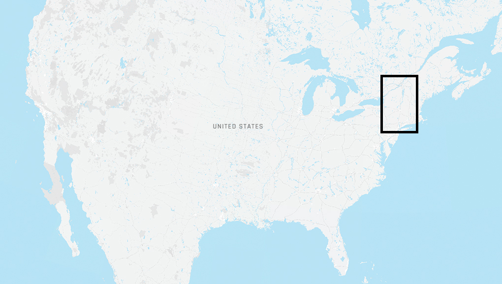
Northeast US
Total flood extent:
124 sq mi (322.88 km2)
Average depth at building level :
3.28 ft (1 m)
July 14, 2023
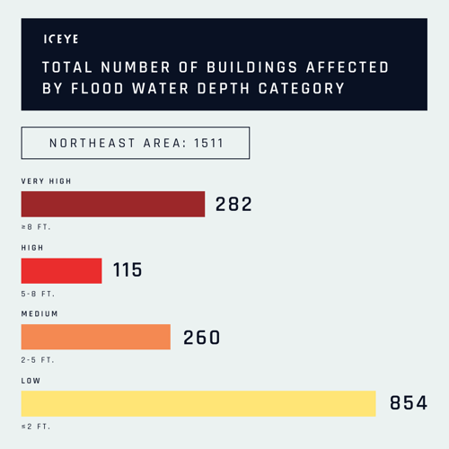
The fourth release of analysis for this event has been mapped and will be delivered to our customers with two new AOIs (areas of interest) included.
-1.png?width=500&height=633&name=image%20(8)-1.png)
July 13, 2023
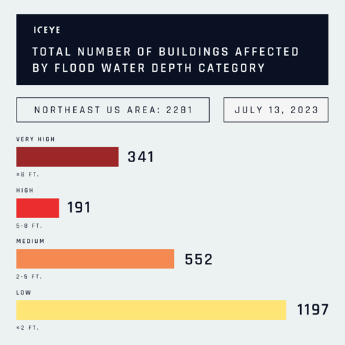
According to our most recent data, over 2000 buildings have been impacted during the floods in Northeast US. Our team has produced the second round of analysis for this event, including the number of affected buildings and inundation. The 3rd release of this event is expected to be delivered today.

July 12, 2023
We are actively supporting federal, state and local agencies with our observation-based flood extent and depth analysis for their use in #DisasterResponse activities during the Northeast US flooding. If you want to know more, contact our Team today and get access to ICEYE's flood analysis with building-level impact data.
July 12, 2023
See a selection of before-after flood impact visuals from Vermont state, including Highland Falls, Montpelier, and Ludlow.
July 12, 2023
Our Flood Team is closely monitoring the floods in Northeast USA. Combining the observed flood extent and depth data from ICEYE satellites with auxiliary data sources, we are working on a new data release with several new AOIs (areas of interest) and are updating some previous AOIs from our first release.
.png?width=500&height=403&name=image%20(44).png)
In the image above, you can see new and repeated AOIs combined. Yellow polygons represent AOIs that we analyzed previously, while the red polygons illustrate new areas that we are adding to our analysis.
July 12, 2023
Our initial data suggests >650 affected buildings with a water depth of at least 2 feet.

Please note that our analysis of the flood situation is ongoing, and the information presented is subject to change.
July 11, 2023
So far, the Catskill Mountains in southern NY and the Green Mountains in VT have experienced the most severe impacts, with more than 5 inches of rain in 24 hours. Vermont’s capital, Montpelier, is under several feet of water from flooding on the Winooski River. The river levels in Rutland, Montpelier, and Johnson, VT have exceeded their peak. The crest is now progressing downstream towards Johnsonville and Burlington, VT, which is anticipated to peak before the day's end Eastern Time.
On the eastern side of the state, the Connecticut River is already experiencing minor flooding as far down as northern CT. The forecasts predict a single crest moving downstream, expected to reach Massachusetts on Wednesday and Connecticut on Thursday. We have scheduled SAR imagery acquisitions along this river through the entire duration of the event.
No substantial rainfall is expected until at least midday Thursday, but the possibility of rain increases as we move into the weekend, with forecasts indicating the likelihood of 1-2 inches of rain, and up to 3 inches in local areas. Given the recent weather patterns of rain and flooding, combined with other incidents from the past few weeks, there is an increased risk of further flooding.
July 11, 2023
The first release of the Flood Insights product was delivered to our customers on July 11, 2023 by 23:00 UTC.
.png?width=500&height=395&name=image%20(43).png)
The above image shows the AOIs (areas of interest) covered in our first analysis release. Please note that our analysis of the flood situation is ongoing, and the information presented is subject to change.
July 9, 2023
After several weeks of repeated rainfall soaking the region, the heavy rainfall during July 9-10 caused significant flooding across portions of the Northeast. Particularly hard-hit were the Catskill Mountains of southern New York and the Green Mountains of Vermont, with both locations seeing more than 5" in less than 24 hours. In Vermont, the flooding is on par with the remnants of Hurricane Irene in 2011. According to our forecasts, river flooding along the Connecticut River will continue through at least 13 July.We've started the event monitoring utilizing the capabilities of SAR satellite constellation and our auxiliary data sources.

Explore our collection of near real-time flood mapping and analysis from across the globe.
March 2026
Download ICEYE's analysis on flooding from remnants of Typhoon Halong.
March 2026
Download ICEYE's analysis on the severe flooding and wind damage from Ex-Tropical Cyclone Alfred
November 2024
Download ICEYE's analysis on the severe flash flooding from the DANA Storm in November 2024.
Sign up for our Insurance solutions newsletter for regular updates about ICEYE products and get exclusive insights on the most pressing natural catastrophes delivered to your inbox.
Connect with our team to explore how ICEYE's natural catastrophe monitoring solutions can enhance your organization. Gain access to near real-time hazard and damage data for informed decision-making.