Contact us
Get in touch with our experts to find out the possibilities daily truth data holds for your organization.
Disclaimer: The impact numbers are subject to change as ICEYE continues to analyze the flood and extend the analysis area. Some areas which have been impacted by the flooding may not be represented in this initial data.
September 20, 2024
As of September 20, we have delivered six flood analysis reports for Poland and three for Austria. Based on our latest data release for Poland and Austria on the Esri ArcGIS platform, we estimate that over 20,000 buildings in the South of Poland and at least 5,000 buildings in Austria may be impacted by the flooding.
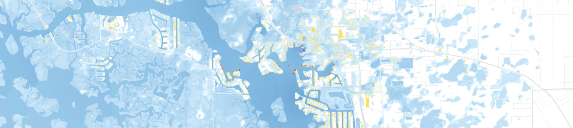
The image gallery below shows a selection of ICEYE flood extent and depth visuals, taken from our sixth data release for Poland and the third release for Austria in Esri ArcGIS.
Key to the image colors: Red - High. Orange - Medium. Yellow - Low.
Colors indicate the total number of buildings affected by flood water depth category.


September 19, 2024
As of September 19, we have delivered five flood analysis reports for Poland and three for Austria. Based on our fifth data release for Poland in Esri ArcGIS, we estimate that at least 20,000 buildings could be impacted by the flooding in the South of Poland.
Boris has finally shifted out of the region, bringing an end to the rainfall in Austria, Czech Republic, and Poland. ICEYE is still monitoring Boris, though, as the heavy rainfall risk has shifted into parts of Italy this week.
The image gallery below shows a selection of ICEYE flood extent and depth visuals, taken from our fifth data release for Poland in Esri ArcGIS. For more data visualizations, you can visit our Esri ArcGIS dashboard.
Key to the image colors: Red - High. Orange - Medium. Yellow - Low.
Colors indicate the total number of buildings affected by flood water depth category.


September 18, 2024
"ICEYE is cooperating with local, national and Pan-European agencies to deliver near real-time flood data to support the emergency response efforts around Storm Boris. Throughout this crisis, our teams will continue leveraging our advanced satellite technology to provide insights and a clearer picture on the ground for emergency responders across Europe," explains Stephen Lathrope, our SVP of Solutions at ICEYE.
As a Gold Esri Partner, ICEYE provides observed flood extent and depth data layers via ArcGIS to aid disaster response for Storm Boris. According to our current analysis release, at least 15K buildings could be impacted by the flooding only in the South of Poland.
You can scroll through our image gallery of some Polish locations impacted by Storm Boris below. Alternatively, you can also download a PDF of the visuals in higher resolution.


September 18, 2024
As of September 18, we delivered four flood analysis reports for Poland and two for Austria. The next analysis releases for these countries are underway.
"In a crisis situation, quick cooperation between public institutions and private entities is crucial in ensuring adequate measures to protect communities. ICEYE has been providing assistance to the mitigation and response efforts across Europe for Storm Boris since its beginning, and we are grateful for the trust in ICEYE’s support during the devastating natural catastrophe unfolding in Europe. Our team is committed to providing continued analysis and insights to the communities impacted," said Rafal Modrzewski, CEO, and Co-founder of ICEYE.


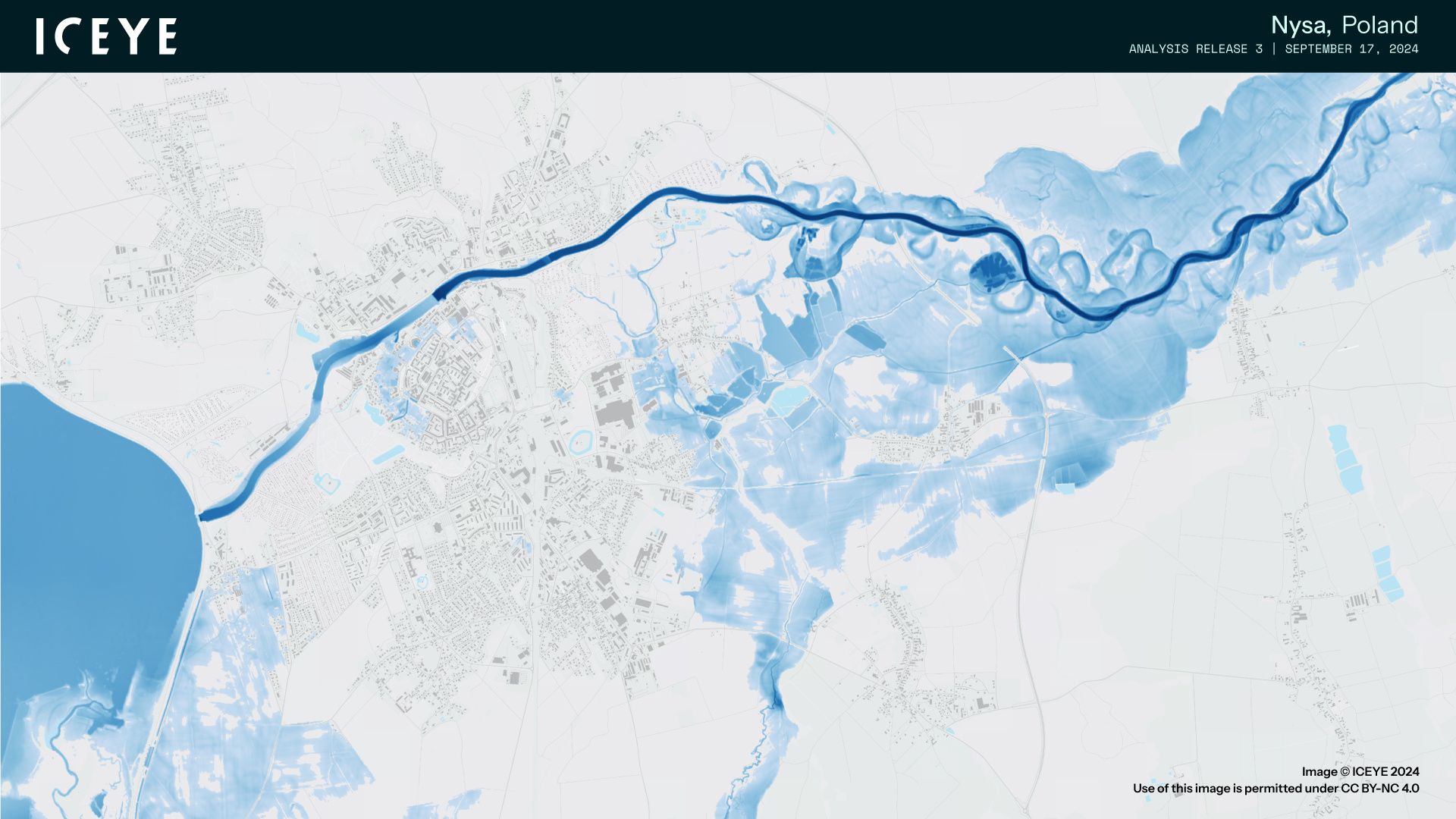
September 17, 2024
We have now delivered three flood analysis reports for Poland and the first report for Austria, with more updates for these countries underway. Our satellites are also actively capturing data from other flood-affected regions across Central and Eastern Europe.
To observe the impact, view the gallery of flood maps from Poland, based on today's 3rd release of our flood extent and depth analysis.


September 17, 2024
Based on our newest, third analysis release for Poland, we delivered an updated news bulletin for the local media, focusing on the affected Polish locations.
In this PDF, you can find visuals for locations such as Nysa, Prudnik, and Jelenia Góra.

September 16, 2024
Storm Boris brought several months' worth of rain in just days over Central and Eastern Europe.
With over 300mm of rainfall reported in some areas, what's the extent of the flooding in Poland, Austria, the Czech Republic, and beyond? How can early-season Alpine snowfall impact river levels through late September?
Read Brandon Wright, our Meteorologist & Solutions Operations Team Lead's summary of how ICEYE's radar satellite constellation helps disaster response in the affected regions.
"Storm Boris has been "stuck" over Central and Eastern Europe since September 12, cut off from the primary jet stream flow. Boris, tapping into the warm and humid air over the Mediterranean Sea, generated prolific rainfall across parts of Poland, the Czech Republic, Slovakia, and Austria," explains Brandon.
“Many locations received several months' worth of rainfall in a matter of days, with more than 300 mm of rain reported. This caused catastrophic flooding in southern Poland and eastern Czech Republic, which will continue for several days as the runoff from the heavy rainfall works downriver into the region's primary rivers. Though Boris has weakened, rainfall continues across parts of the region, including Austria,” adds Brandon.
The Danube has also seen flooding issues, including around Vienna and Bratislava. In addition, Boris brought early-season snow to the higher elevations of the Alps, with nearly 1m of snowfall observed. This will melt in the coming days and prolong river flooding in the region through late September.

Flood extent and depth in Krapkowice, based on the second release of ICEYE’s flood analysis from September 16, 2024.

Flood extent and depth in Przyłęk, based on the second release of ICEYE’s flood analysis from September 16, 2024.
September 16, 2024
Based on our R2 analysis release for Poland, we prepared a news bulletin for the local media, focusing on the affected Polish locations.
In this PDF, you can also find visuals for locations such as Kłodzko, Stronie Śląskie, Przyłęk, Krapkowice, and Glogow.


November 2024
Download ICEYE's analysis on the severe flash flooding from the DANA Storm in November 2024.

October 2024
Download ICEYE's analysis on the flooding from Hurricane Milton in October 2024.

October 2024
Download ICEYE's analysis on the flooding from Hurricane Helene in September 2024.