Contact us
Get in touch with our experts to find out the possibilities daily truth data holds for your organization.
Historically, SAR required the use of extremely costly 1,000 kg satellites, which made it the preserve of secret intelligence agencies and large government programs such as NASA and the European Space Agency (ESA). In recent years, however, ICEYE has widened the availability of SAR technology to launch a constellation of smaller, lighter satellites that are much quicker and cheaper to develop and build.
In this quick introduction to SAR, we’ll take you through the basics of how it works and explain some of the key terms and concepts you’ll need to know if you want to understand the technology in more detail.
SAR works by sending discrete radar pulses from an antenna to the ground, accumulating data from each pulse’s echo, and then processing that data to form high-definition images of the earth’s surface.
Accurate measurements
The reason SAR can make such accurate measurements is because it uses coherent illumination. In other words, it sends out only one wavelength of light (at ICEYE, we use X- band microwaves, which are 3 cm long). This contrasts with the chaotic illumination of sunlight, which comprises photons of many different wavelengths including blue light, green light, ultraviolet light and infrared light.
Advantage over optical
The other advantage SAR has over optical camera technology is that it is equally capable of working through clouds and in darkness, so it can capture clear images any time of the day or night.
Aperture refers to the opening used to collect radar data. The size of this opening is important because the longer it is, the better the radar’s ability to distinguish between two closely spaced objects.
An antenna using SAR technology sends out thousands of radar pulses a second while moving in orbit around the earth. In so doing, it extends the opening used to collect the data to whatever distance it travels during that time. This distance, which underlies SAR’s ability to produce images of such high quality, is called the synthetic aperture.
The SAR antenna measures the range, brightness and phase of each wavelength.
Range is the distance from the antenna to the ground.
Brightness is the strength of the echo. When the pulse hits the ground, it reflects in many directions. The part that comes back to the antenna is called the backscatter. Strong backscatters equate to bright pixels and weak backscatters equate to dark ones.
Phase is the state of the wave when it returns to the antenna (is it at its peak, its trough or somewhere in between?). The ability to measure phase with high levels of accuracy has led to some extraordinary scientific achievements, including the Nobel Prize-winning 2015 observation of Einstein’s gravitational waves.
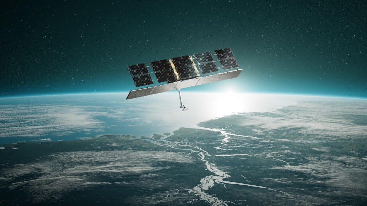
When using an optical camera to create images of the earth’s surface, you get the best possible resolution by looking directly down at the ground.
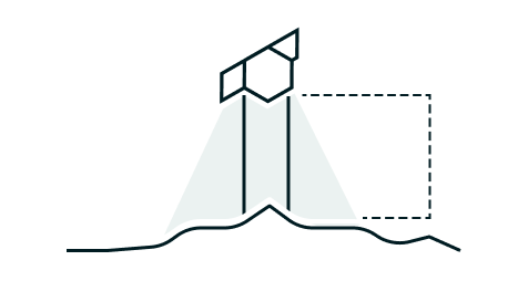
For SAR, however, this simply doesn’t work because when you illuminate the ground vertically, points in different places can have the same range – and, as we saw above, range is one of the key measurements that help form the image. We therefore need to use a side-looking angle instead.
Vertical illuminations do not work because two different points can have the same range
With a side-looking illumination, every point on the ground has a discrete range
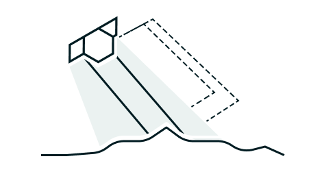
Most SAR antennae illuminate broadside, that is at 90 degrees to the flight path. The angle between the line-of-sight ray and the tangent to the ground is referred to as the grazing angle. The angle between the line-of-sight ray and the local vertical is known as the incidence angle.
The two of them together form a right angle, so that, for example, a 30- degree grazing angle is equivalent to a 60-degree incidence angle.
Line of sight
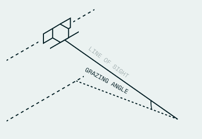
Grazing angle
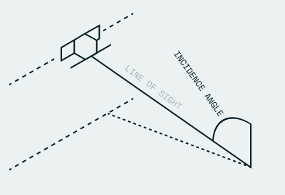
Incidence angle
The two resolutions we talk about when using radar are azimuth resolution and range resolution.
Azimuth resolution relates to the dimension along the flight path, known as azimuth range. Range resolution relates to the range along the ground surface, known as ground range.
The important value for SAR is range resolution because images are built on the ground.
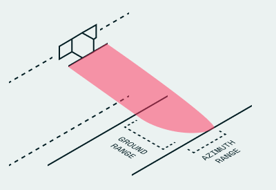
Ground range and azimuth range.
SAR has four different imaging modes: Spotlight, Strip, Scan, and Dwell.
Spotlight mode is the highest resolution mode. In this mode, the illumination angle changes as the antenna moves along its flight path so that the illumination remains focused on the same area of ground. It is like shining a spotlight on a single location, hence the name. As you can imagine, spot mode allows us to capture an image of a small ground area using a very long synthetic aperture. The satellite travels at 7.5 km per second in low-earth orbit and can illuminate the same area of ground for up to 20 seconds, which creates a synthetic aperture of 150 km. In this way, SAR massively increases the effective size of our antenna: an object that is in fact a mere 3 m behaves like an object 50,000 times as long. Learn more about the different ICEYE Spot modes..
Strip mode is a medium resolution mode. In this mode, the illumination angle is fixed, which means you get a much larger image but at lower resolution. ICEYE standard Strip products have a ground resolution of 3m in range and azimuth and cover an area of 30km (range) by 50km (azimuth). The strip length can be tailored up to a length of 500 km, in increments of 50 km.
Scan mode gives you only modest resolution but over large swaths of land. In this mode, the incidence angle keeps changing as the antenna moves along so that pulses are sent to the ground in multiple overlapping strips. This allows you to sweep over a very wide ground area within a single illumination.
Dwell mode is a very long spotlight mode SAR collection. The antenna size and smaller mass of ICEYE satellites allows them to stare at the same point for as long as 25 seconds. This results in a very fine azimuth resolution. The additional information acquired in the azimuth direction is utilized to form highly multi-looked amplitude products (20 looks) with significantly reduced speckle. Additionally, 'Color Sub-Aperture Image (CSI)' product and 'SAR Video' are produced from Dwell acquisitions. Learn more about the different ICEYE Dwell modes.
SAR expert Tom Ager demystifies SAR technology and describes the basics and benefits of the technology. Watch 'Join the SAR journey', the first episode in our Value of SAR series.
