Contact us
Get in touch with our experts to find out the possibilities daily truth data holds for your organization.

ICEYE has been monitoring the storm since its formation, acquiring 150+ SAR satellite images of the impacted areas through thick storm clouds and even at night.
Before and after in Asheville, North Carolina, one of the hardest-hit cities. This visualization is based on the third ICEYE flood extent & depth analysis report from September 30, 2024.
After making landfall, Helene continued moving inland, leaving a trail of flood and wind destruction in Florida, South and North Carolina, Georgia, and Tennessee through the weekend.
We delivered the first flood extent and depth analysis on September 27th, focusing on the west coast of Florida. Since then, eight more releases of our flood analysis have been produced, covering additional areas in the Florida panhandle, Georgia, and the Southern Appalachians.
Based on THE OBSERVED data from our fINAL, 9th ANALYSIS RELEASE, over 160,000 buildings have been impacted across Florida, North Carolina, Tennessee, Georgia, Virginia, South Carolina, and West Virginia, with approximately 17,000 buildings inundated by over 60 inches (5+ feet; 152+ centimeters) of water.
Our team of flood experts closely monitored the situation and provided near real-time flood extent and depth information to emergency management organizations, public authorities, and insurance companies in the region.
For a closer at the most affected locations, you can download our Flood Briefing PDF here.
ICEYE data and analysis were also featured in top-tier media, covering Hurricane Helene:
Based on ICEYE's fourth analysis from September 30, hundreds of buildings have been inundated in Buncombe County, North Carolina. The visuals below, produced with Esri ArcGIS, show the flood's impact in and around Asheville, one of the hardest-hit cities.
 Flood extent and depth in Buncombe County, NC, based on the fourth release of ICEYE’s flood analysis from September 30, 2024.
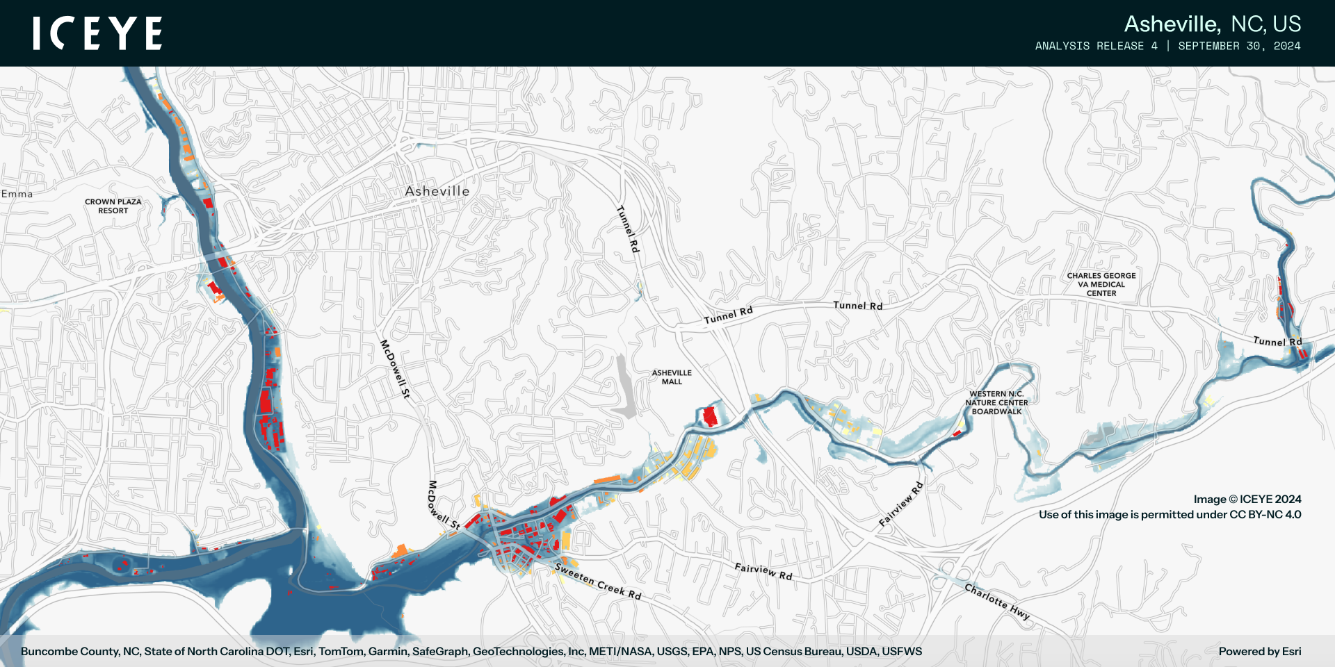
 Flood extent and depth in Asheville, NC, based on the fourth release of ICEYE’s flood analysis from September 30, 2024.
 Flood extent and depth in and around the Biltmore Village, Asheville, NC, based on the fourth release of ICEYE’s flood analysis from September 30, 2024.
 Flood extent and depth in and around the River Arts District, Asheville, NC, based on the fourth release of ICEYE’s flood analysis from September 30, 2024.
Download our latest Flood News Bulletin from September 30, with imagery included.
 Flood extent and depth in Atlanta, GA, based on the third release of ICEYE’s flood analysis from September 30, 2024.
 Flood extent and depth in Asheville, NC, based on the third release of ICEYE’s flood analysis from September 30, 2024.
 Flood extent and depth around St. Petersburg and Tampa, FL, based on the third release of ICEYE’s flood analysis from September 30, 2024.
 Flood extent and depth in Charlotte Harbor, FL, based on the third release of ICEYE’s flood analysis from September 30, 2024.
The first flood extent & depth analysis release was delivered on September 28, indicating that over 80,000 buildings in Florida have been inundated. Based on our second release from September 29, at least 100,000 buildings have been impacted in this state, with more than 1,000 buildings having 8+ feet of water. Here are some of the impacted areas, opened in Esri ArcGIS.
You can download our Flood News Bulletin from September 28 or browse a selection of images from impacted locations below.
 Flood extent and depth in and around St. Petersburg, FL, based on the first release of ICEYE’s flood analysis from September 28, 2024.

Flood extent and depth in and around Tampa, FL, based on the first release of ICEYE’s flood analysis from September 28, 2024.

Flood extent and depth in Charlotte County, FL, based on the first release of ICEYE’s flood analysis from September 28, 2024.

Flood extent and depth along the northwest central coast of Florida, based on the first release of ICEYE’s flood analysis from September 28, 2024.
Our Flood Insights product integrates ICEYE’s advanced SAR satellite imagery with a comprehensive mix of third-party
data. Enhanced by our state-of-the-art algorithms and machine learning, this technology is further supported by the deep expertise of our in-house meteorology and advanced geospatial analytics team.
Our insights smoothly integrate into the claims processing and GIS systems currently employed by insurance companies and public sector organizations, ensuring critical data is delivered efficiently and effectively where it’s needed most.
ICEYE Media contact in the US: Invariant, iceye-comms@invariantgr.com
ICEYE Global Communications: press@iceye.fi

05 March 2025

19 February 2025

16 December 2024