Contact us
Get in touch with our experts to find out the possibilities daily truth data holds for your organization.
But this season isn’t just about above-average storm counts. The real story lies in the dynamics behind the numbers—a blend of climate signals that will shape what we actually experience. To unpack the latest outlook, we turned to Brandon Wright, ICEYE’s in-house meteorologist, for a closer look at the four key factors influencing the 2025 hurricane season—and what they could mean in practice.
In this 10-minute video briefing, Brandon walks through:
As Brandon notes, this year’s forecast points to “a named tropical storm [being] active for nearly three months”—but how, when, and where those storms emerge is where attention to the details truly matters.
Let’s start with ocean temperatures. The Atlantic—especially the Gulf of Mexico and Caribbean—is still running warmer than average. That’s the fuel tropical systems feed on.
Brandon points out that we’re not quite at last year’s record warmth, but there’s enough energy in the water to support strong storms. And while it might not be enough for a Category 5 in June like it happened with Hurricane Beryl in 2024, the earliest Category 5 Atlantic hurricane on record, the heat is there, and that could cause significant storms to form this season as well.
Then there’s the ENSO cycle, which influences how storms behave once they get going. Models suggest we’re headed toward neutral or weak La Niña conditions during the heart of the season. For the Atlantic, that often means reduced wind shear, which is a more favorable environment for storm organization.
Two other factors deserve more attention than they usually get. First: rainfall in the Sahel. When that narrow stretch between the Sahara and the savanna sees a wetter season, it often leads to more active tropical waves—some of which evolve into hurricanes as they move west across the Atlantic, and this year’s early signals suggest more rain.
The second factor is the Saharan dust. “If there is a lot of dust, numbers are down. If there isn’t, numbers can be up,” Brandon reminds us. It doesn’t make headlines, but it should.
Dust can stifle thunderstorm activity by drying out the atmosphere and cooling ocean surface temperatures. Last July, for example, dust was one reason much of the month was quieter than expected. The tricky part? There’s no good long-range forecast for dust, so it remains a persistent wildcard.
If we add it all up, and this season isn’t just a numbers game—it’s a layered set of probabilities, with different climate signals pulling in competing directions. For instance, while La Niña may clear the path for stronger storm development by reducing wind shear, even a modest increase in upper-level winds can disrupt vertical storm organization, causing cyclones to fall apart before they gain strength. It’s a reminder that timing and geography are everything: a favorable setup in the central Atlantic may not apply closer to landfall zones.
Meanwhile, the Saharan dust wildcard isn’t just about whether storms form, but how long they survive. A dusty wave that emerges off the African coast may sputter, while a clearer path can fuel a long-tracking major hurricane. As Brandon points out, that unpredictability is part of the reason July 2024, despite early activity, fell into a lull.
It requires watching, interpreting, and adjusting. Models give us scenarios, but observations tell us what’s real.
That’s why it matters to be able to see what’s happening, not just what might happen. Observational tools, especially those not hindered by cloud cover or daylight, give decision-makers the ability to respond with confidence.
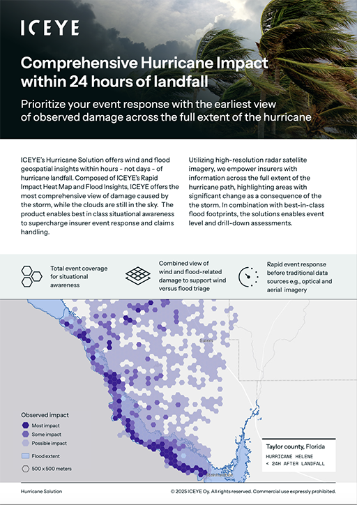
ICEYE's monitoring of all Atlantic Basin tropical cyclones for a potential landfall, combined with our all-weather, day or night SAR constellation, gives us a unique advantage in the immediate aftermath of a hurricane landfall. It allows us to provide rapid and large-scale insights into the damage and destruction, improving the speed and accuracy of response and recovery.
Whether you're managing claims, coordinating emergency logistics, developing public policy, or overseeing financial risk exposure, 2025 is shaping up to be a season that rewards a deeper understanding. Not just of meteorology, but of the limits of our predictive systems.
These early seasonal forecasts start the conversation, but ultimately, it’s the observations that really matter. This year, the real advantage will go to those who are ready to track, question, and act in real time.
“While the forecast from Colorado State is for an above-normal season, what stands out to me are some of their other probabilities: greater than a 50% chance of a major hurricane tracking through the Caribbean, and also greater than a 50% chance of a major hurricane landfall. As we've seen in recent years from Hurricanes Milton, Ian, and Ida, these major hurricane landfalls bring significant destruction to a large area. Oftentimes, these landfalls are life-altering events, dramatically changing both the natural landscape and the human landscape”, concludes Brandon.
If you’re interested, you can explore ICEYE’s Hurricane Solution for insurers here, and our Hurricane season offering to public sector organizations here.
Hurricane Solution Info Pack for Insurers

05 March 2025

19 February 2025

16 December 2024