Contact us
Get in touch with our experts to find out the possibilities daily truth data holds for your organization.
While extreme Santa Ana winds and dense smoke grounded traditional aerial assessment methods, ICEYE’s Synthetic Aperture Radar (SAR) satellites were providing what decision-makers needed most: accurate, timely, and actionable intelligence when it mattered most.
The January 2025 Los Angeles wildfires weren’t just another California fire event. They marked a disturbing evolution in wildfire behavior that demands new approaches to disaster intelligence:
For insurers and emergency managers, these fires exemplified the new normal: catastrophic events where traditional information sources falter precisely when accurate data becomes most critical.

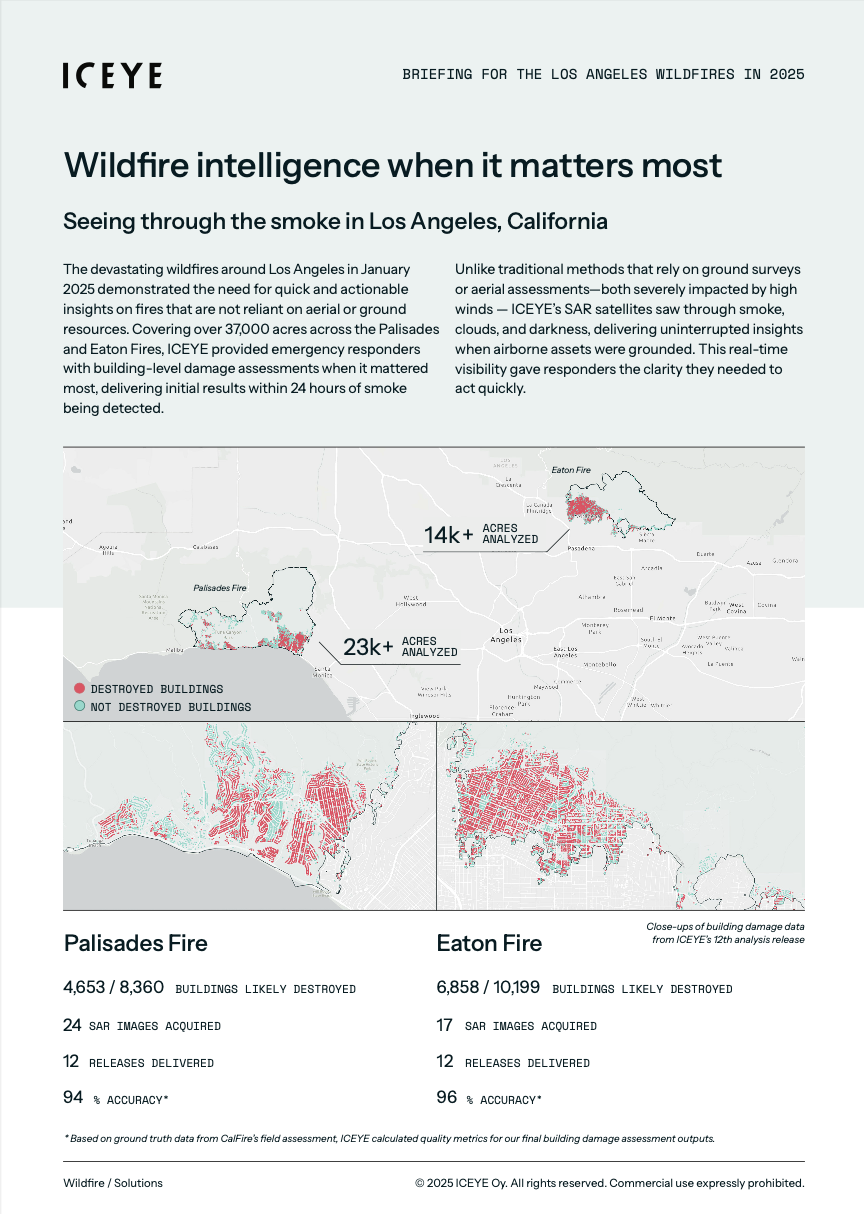
It is fair to say that the performance metrics from our Los Angeles wildfire response demonstrate why ICEYE is becoming the trusted source for natural catastrophe intelligence. Below is a summary of our key metrics, based on ground truth data from CAL FIRE’s field assessment.
For the Palisades Fire (23,000+ acres):
For the Eaton Fire (14,000+ acres):
"What these numbers really show is that 99% of the buildings we identified as destroyed were in reality destroyed," explains Penelope Kourkouli, our Wildfire Insights Product Manager at ICEYE.
"When we achieve this level of precision, it can be a game-changer for organizations making high-stakes decisions under extreme time pressure, allowing them to take decisive action rather than waiting for confirmation."
ICEYE's analysis performance assessment throughout our 12 data releases for the Eaton Fire, based on ground truth data from CAL FIRE’s field assessment.
When the Palisades Fire erupted on January 7, decision-makers experienced a critical information shortage:
"This is exactly when reliable observed data becomes most valuable," explains Penelope.
"The early stages of a rapidly evolving disaster create a significant information gap that directly impacts both operational response and strategic decisions."
When responding to catastrophic wildfires, observed data provides what models and predictions cannot – observational insights that first responders can trust. For insurance leaders, this means being able to set proper reserves from day one and allocate claims resources efficiently based on verified damage. Meanwhile, emergency management teams can maintain situational awareness even when ground access is impossible, enabling more effective evacuation and response planning and ultimately, more efficient and successful recovery.
ICEYE operates the world’s largest SAR satellite constellation, providing high-resolution, all-weather monitoring for natural catastrophes. However, our wildfire analytics service isn’t about delivering satellite images. Instead, we offer actionable geospatial insights so emergency management agencies don’t need to request data manually. Our methodology includes:
 ICEYE's event overview and deliverables timeline for the LA wildfires.
"Our approach prioritizes covering the full perimeter first, and then we revisit previous areas that we’ve assessed before," notes Penelope.
The Los Angeles wildfires presented unique challenges that showcased the sophistication of ICEYE’s analytical capabilities.
Evolving fire conditions
"During the early stages of a fire that’s still unfolding, buildings that initially appear intact may be damaged later as the fire progresses," Penelope explains. "That’s why our radar satellite revisit strategy is so critical – it captures these changes as they occur."
This dynamic assessment capability was particularly evident during the Palisades Fire, where a significant improvement in detection occurred between our fifth and sixth releases as we revisited previously assessed areas.
Challenging terrain
The topography around Los Angeles presented additional analytical challenges. "The varied topography in the Los Angeles region posed challenges for our analysis. To overcome visibility limitations in these areas, we acquired imagery from a range of acquisition angles", explains Aymeric Mainvis, our Team Lead (SAR Analytics R&D) at ICEYE. "This strategy significantly reduced false positives in later releases," Aymeric adds."
The Los Angeles wildfires revealed two important insights about effective disaster intelligence.
Timeliness transforms value
"Our analysis showed that delivering initial results within 24 hours of smoke detection provided critical early intelligence," Penelope explains. "But equally important was our ability to deliver daily updates as conditions evolved."
This timeliness factor represents a fundamental shift in disaster response. When observed damage data can be available weeks before the ground assessments are completed, it enables an entirely different class of situational awareness for teams on the ground.
This slider from our Esri StoryMap shows ICEYE Wildfire Insights Release 12 for the Palisades Fire on the left, and the Ground Truth data from CalFire on the right.
Damage assessment strategy matters
"During these events, we identified a key insight about assessment strategy," Penelope notes. "Our current approach, which prioritizes initial full perimeter coverage followed by reassessment of previously analyzed areas, requires refinement. To optimize response efforts, we need to prioritize high-impact, densely populated areas for more frequent reassessment and building damage assessment updates."
This evolution in assessment methodology demonstrates how each major event contributes to continuous improvement in disaster intelligence.
As climate change increases both the frequency and severity of wildfires worldwide, the Los Angeles events offer valuable guidance for the entire catastrophe response ecosystem:
"The most important lesson from these events is that observed data fundamentally changes response capabilities," concludes Penelope.
For insurers and emergency managers facing increasingly frequent and severe wildfire events, this level of accuracy isn’t just helpful – it’s essential for effective disaster response in our changing climate.
If you are interested in downloading our analysis summary in a PDF format, click below.
Los Angeles Wildfires Briefing PDF

11 December 2025

28 October 2025

15 October 2025